The JAM Hike Trip Report
Peaks Hiked
Route
Trip Report
This is the J.A.M. hike, a Norther Presidential traverse. It was brutal. Not fun. Rocks, rocks, rocks. It was all rocks. The most grueling hike I’ve done. [2008 note: It was the most physically exhausting trip of the 48s and far more difficult than the 2007 Zealand-Bonds traverse which was an additional 6 mi. and 2.5 hrs. but 1,500 ft elevation less.]
The Jewell Tr. is a jewel – beautiful in both directions and easy going to treeline. The rest of the trip, well, there’s not much to say except brutal, rocks, grueling, rocks. The Northern Presis are far more rugged than the Southerns.
I was exhausted by the time I reached Jefferson’s summit. I should have turned back but I couldn’t shake the regret of not summiting Madison in 1990. I didn’t want to miss it again and have to climb up here a third time. Jefferson’s summit cone was dramatic and crowded with hikers. It was composed of giant-sized boulders that took a significant effort to scramble up. Having to walk around lounging hikers who didn’t seem to care if they were sitting on the trail made it more difficult. Monticello Lawn was a field of long, brown grass below the summit. It looked as if someone had planted grass on the moon and left hoping moon rain would keep it looking good. It wasn’t looking good.
The cols between summits were significant drops. The terrain from Edmands Col to Thunderstorm Jct. was lovely. The T-storm Jct. cairn looked sadly knocked down from something that was once prouder. The climb up Adams was a lot of work rock hopping on the tops of giant pointed boulders. Falling in between them would make for a bad-assed skinned knee. Adams summit view into the Great Gulf and across Star Lake, Madison Hut and Madison summit was the best of the day. The climb to Madison’s summit was the most civilized of the three. Rocks, yes, but they were Adams sized and butted tightly like Jefferson’s. The top, though, was spooky narrow with a high wind. I was afraid of blowing away.
Valley Way was very eroded at the top, much more than I remembered from 1990. It’s a long walk down.
Of note
- clouds and sun, breezy, upper 70s in the valley
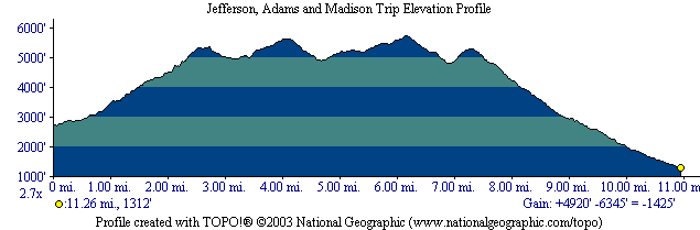
- 14 mi, 10 hrs, 5,200 ft elevation gain
- This should not have been done as a day hike. It was a punishment, not enjoyment. Not fun. I was emotionally drained when it was over. I wept at the end of the hike. I regret hiking this route.
- I was so exhausted walking out of Edmand’s col that I gagged and started to vomit. I thought, If I throw up I’m a dead man. I swallowed it back down and kept hiking.
Profile